
As an officer, you must be proficient in the art of military map reading. All operations that are in liaison with active and reserve military units will always use military maps in their execution and operations orders. You will be expected to have the skills necessary to follow those instructions. Refer to FM 21-26, Map Reading and Land Navigation.
Practical testing in map reading skills will be an important part of your OTC program. Areas of testing are:
The first thing you should know about a map is that it is nothing more than a drawing of a piece of the earth's surface as it would be seen from above looking straight down.
Your map shows much more than just terrain. It shows physical symbols for man-made objects such as roads, buildings, etc., and topographic symbols identifying terrain features. All of these objects are represented on the map by a symbol, and these symbols are explained in the lower left corner of every map in a section called the LEGEND. Learn how to use the Legend.
The Legend also gives you information about the color codes used on the map. Know what the colors are and what they represent. Finally, the map also gives you crucial information in its margins, such as scale, date of printing, and in the bottom margin the Grid/Magnetic angle (difference between magnetic north, map grid north, and true north for your map.
There are no street addresses on your map, but you can still find your LOCATION accurately. Your map has black lines running up and down (North and South) and crosswise (East and West). Together they form squares called GRID SQUARES. Their lines are numbered along the outside edges of the map. Each grid Square has a different number. To get the correct number for a certain square, first read from left to right along the bottom edge of the map and find the line that borders the left side of your grid. Then read UP and find the East-West line that is the bottom border of your grid square. In other words, read RIGHT then UP. Using your map protractor, determine a six-digit grid coordinate to locate a point on the ground within 100 meters. Then determine an eight-digit grid coordinate to locate a point on the ground to within 10 meters. Record the grid coordinates with the correct two-letter grid square identifier. Refer to FM 21-26.
| At a level spot, place a stick into the ground vertically so it casts a distinct shadow. Mark the shadow's tip with a stone see in figure). Wait 10 minutes or more and mark the new position with a second stone, then draw a line through the centers of the two stones. This drawn line is an EAST-WEST line. The first stone that you put down is WEST and the second is EAST. | 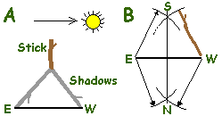 |
Now draw a vertical line perpendicular to the EAST-WEST line to give you the NORTH-SOUTH line (B). Do this by taking a stick, hold one end of it on the West end of the line, and draw two arcs above and below the E-W line (see B in the fig-ure). Then hold the stick on the East end of the line and draw two arcs above and below the E-W line, intersecting the first two arcs. If you draw a straight line between the two arc intersections, this will be the N-S line.
| Direction with your watch: You can also find direction with your watch, but not as accurately as the shadow-tip method. Point the hour hand at the sun. South will be half way between the hour hand and twelve o'clock. | 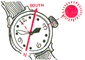 |
| You can locate north at night by finding the North Star. Find the Big Dipper. The last two stars on the cup point directly at Polaris the North Star which is about five times as far out as the distance between those two stars in the cup. Facing the North Star, you are looking north with East on your right and West on your left. | 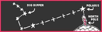 |
| The grid/magnetic angle in the lower margin of your map can be important to you. In many parts of the world your compass does not point due (grid) north, but varies some degrees right or left. The North-South lines on your map point the direction to Grid North. The needle of your compass always points to Magnetic North. Neither one points straight at the North Pole. The Grid/Magnetic angle in the map margin tells you how much they vary. | 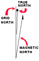 |
Take a bearing (azimuth) to the water tower, and calculate the reverse bearing, or back azimuth. Place your protractor's center on the water tower symbol, and orient its top edge parallel to the East-West lines on the map. Mark a spot on the map at the protractor's edge where the reverse bearing is located. Draw a line from the tower symbol to tnd through that spot. Do the same with a second object you can see which is also on the map. Where the two lines cross is your location.
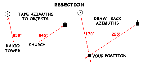
Alternately, GTA 5-2-13 has several methods of resection that you should be familiar with--study them.
| Modified resection works well when you know that you are already located on a feature, such as a road or a trail. You only need to take the back azimuth from a single object, say a school. You are located where the drawn back azimuth line crosses the feature you are on. | 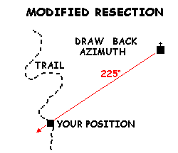 |
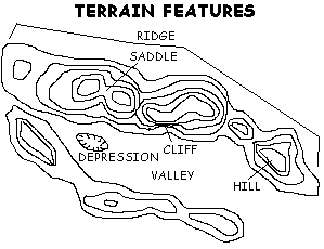
Every fifth line is printed heavier than the rest and has a number that gives the elevation of that line in feet. Find your position between the heavy brown contour lines and simply read the value, adding the lines as you close in on your position. GTA-5-2-13 has some good examples--study them.

| Black: Indicates cultural (manmade) features such as buildings and smaller roads, trails (dashed lines), surveyed spot elevations, and all labels. | |
| Red-Brown: On red light-readable maps, the colors red and brown are combined to identify cultural features, all relief features, nonsurveyed spot elevations, and elevation, such as contour lines. | |
| Blue: Identifies hydrography or water features such as lakes, swamps, rivers, ditches, canals and drainage. | |
| Green: Identifies vegetation with military significance, such as woods, orchards, swamps, windbreaks, vineyards and crops. | |
| Brown: Identifies all relief features and elevation, such as contours on older edition maps, and cultivated land on red light-readable maps. | |
| Red: Classifies cultural features, such as populated areas, built-up areas and cities, large (main) roads, and boundaries, on older maps. | |
| Other: Occasionally other colors may be used to show special information, such as yellow for cities and towns. As a rule these are indicated in the marginal information. |
| Trees | Green symbols, which may be organized in rows to illustrate an orchard or planted forest. | |
| Roads | Solid lines or red or black. | |
| Unimproved roads | Double dashed lines. | |
| Trails | Dotted lines. | |
| Bridges | Elongate brackets with wings on either side of a road or railroad. | |
| Railroads | Solid lines with small cross-lines. | |
| Buildings | Large ones are shown in black shapes, small ones as small squares. Churches have a small cross atop, and schools a small flag. | |
| Towns | Shown as a small black circle (small) or an outlined red circle (larger). | |
| Cities | Shown as a line-bounded area filled with pink or yellow. | |
| Storage tanks | Shown as a small or large circle with the contents as a label, i.e., Oil. | |
| Towers | Radio, TV, electrical towers are shown as a small black circle with a dot inside, and the word Tower alongside. | |
| Power lines | A series of spaced small circles connected by dashed lines. | |
| Fences | A series of spaced small Xes connected by straight lines. | |
| Airports | Shown with true runway shapes in black. | |
| Elevations | May be shown with the BM mark, or on smaller scale maps as simple spot elevation numbers with no symbol. |
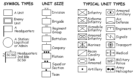
Ideally, different colors are used to depict enemy and friendly symbols. Since different colors may not always be available, procedures for one-color and multicolor symbols are as follows: Friendly symbols are outlined by a single line; Enemy symbols with double lines. Blue or black indicates friendly units, posts, etc. not covered by other colors. Red indicates enemy elements. Yellow indicates chemical or radiological areas. Green indicates friendly and or enemy manmade obstacles. If other colors are used, they must be explained in a legend. (FM 101-5-1, Operational Terms and Graphics)